| Year | Arab | Total |
|---|---|---|
| 1931 | 101 | |
| 1944/45 | 190 | 190 |
| Year | Arab | Public | Total |
|---|---|---|---|
| 1944/45 | 1150 | 1150 |
| Use | Arab | Total | |||||||||
|---|---|---|---|---|---|---|---|---|---|---|---|
|
803 | 803 (70%) | |||||||||
|
347 | 347 (30%) |
The village was located on a hilltop, spread along both banks of a wadi and surrounded by low-lying wadis and hills. A dirt path linked the village to the Ramla-Ramallah highway, less than 2 km to the east, and other, dirt paths connected it to adjacent villages. The village was founded by families from the area who first established farms on the land and then gradually built houses there. Their houses were made of masonry and mud, clustered together and separated by narrow alleys. The entire population was Muslim. A well on the site supplied Khirbat al-Buwayra with water for domestic use. The inhabitants grew grain, vegetables, and fruits; these crops were either rainfed or irrigated with water from several wells scattered around the site. In 1944/45 a total of 316 dunums was allocated to cereals. Thirty-one dunums were irrigated or used for orchards; olives were grown on 25 dunums, and some of the land area served as pasture. A khirba that bore the village's name was located on the outskirts; it contained the foundations of a rectangular building that was equipped with cisterns.
During the second phase of Operation Dani (see Abu al-Fadl, Ramla sub-disctrict), after Israeli units had conquered and depopulated Ramla and Lydda, some units advanced eastwards in the direction of al-Latrun. Khirbat al-Buwayra was probably seized during that push, in mid-July 1948. The sub-operation failed to capture al-Latrun but brought a substantial number of Palestinian villages under Israeli occupation. There is no account of the occupation of this village, but General Yigal Allon, who commanded Operation Dani, was notorious for deporting large numbers of people from areas falling under his control. When the armistice lines between Israel and Jordan were drawn they fell in close proximity to the village.
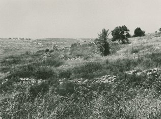
The village has been reduced to rubble, which is scattered over a wide area; only the walls of one big house, made of relatively large stones still stand. The center of the site contains many wells and private gardens, separated by stone markers that also serve as stairs leading down to the wadi. In 1989, a fire burned the almond, fig, olive, and pine trees that grew at the center of the site. Today the village is a military training area.
Related Content
Violence
End of First Truce: Israeli Operations An-Far, Dani and Qedem
1948
8 July 1948 - 17 July 1948


